

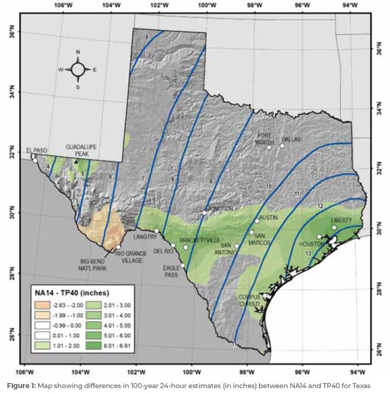
In September 2018, the National Oceanic and Atmospheric Administration (“NOAA”) published a new study, called Atlas 14 Volume 11, that found increased rainfall frequency values across Texas. More specifically, the analysis found that major cities, like Austin and Houston, are more likely to experience a major storm event than previously expected, thus increasing the likelihood of severe flooding (see Figure 1). To prepare for the increased flood risk, the City of Austin has developed proposed changes to the City Code which includes tighter regulations that impact existing and future infrastructure.
The New 100-Year Storm
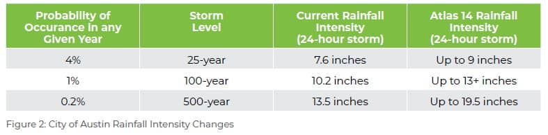
The updated NOAA Atlas 14 results in significant changes to Austin’s rainfall amounts that define the City’s current “100-year storm” event. A 100-year storm is defined as the amount of rain having a one percent chance of being equaled or exceeded in any given year, or 26 percent chance of occurring during a 30-year period.
Based on existing data, the City of Austin defines a 100-year storm event as 10.2 inches of rainfall depth in a 24-hour time period. However, the new Atlas 14 study for Texas shows that this rainfall amount is likely to occur more frequently. NOAA’s Atlas 14 defines the new 100-year storm for the city to be closer to 13 inches of rainfall depth in a 24-hour period, which resembles the current 500-year storm (see Figure 2).
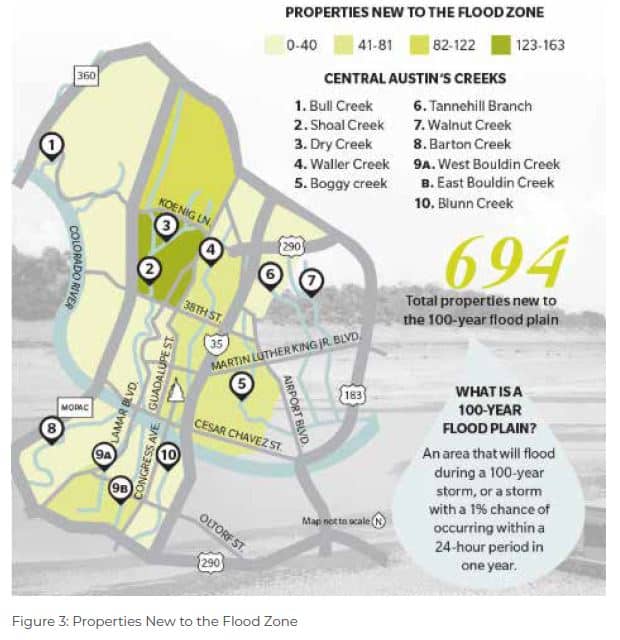
The Atlas 14 study also impacts the existing floodplain zones in the City of Austin. A floodplain is the land which has been or is expected to be covered during a regional flood. Given Atlas 14’s new historical data, this information indicates that more people and property are at risk of flooding. To account for this increased flood risk, the City of Austin is proposing to rezone the City so that the new 100-year floodplain will be based on the existing 500-year floodplain. These new, larger flood zones will encompass nearly 700 more Central Austin properties than before (see Figure 3).
City of Austin Code Proposal
The City of Austin regulates new development, redevelopment and remodeling in the floodplain. These regulations are meant to protect residents from flooding and reduce public expense in the aftermath of a flood. As a result of the Atlas 14 Study, the City of Austin is proposing to change City code in order to protect the public from flooding.
The proposal has four main components, as outlined below:
- The proposal uses an interim 100-year floodplain, based on the current FEMA 500-year flood insurance rate map, to regulate development. This change means that the floodplain regulations will apply to more properties. Property owners and businesses in the interim 100-year floodplain would have new restrictions if they want to develop, expand, remodel or improve their properties. The City of Austin estimate that there are approximately 7,200 buildings in the interim 100-year floodplain.
- The City of Austin includes a new exception that will allow for the administrative approval for redevelopment of a residential building in the floodplain that reduces flood risk. Currently, this often requires approval by the Austin City Council.
- The proposal recommends expanding an existing exception that allows for a building to encroach on the 100-year floodplain of the Colorado River downstream of Longhorn Dam and along Lady Bird Lake to also include Lake Austin and parts of Lake Travis.
- The proposal recommends an increase in the freeboard requirement for buildings from one foot to two feet.
Additional Impacts to Consider
Aside from new City regulations that will impact property owners, the Atlas 14 Study also has additional far-reaching impacts as outlined below:
- Flood Insurance – The City of Austin estimates that the number of buildings in the 100-year floodplain could increase from 4,000 to 7, 200. Affected residents who have federally-backed mortgages will eventually have to purchase flood insurance. Those who already have flood insurance will likely see the costs go up. This will affect businesses, too. Residents and business owners in the interim 100-year floodplain should talk to their insurance agent about purchasing flood insurance. Impacts to flood insurance will occur after FEMA approves updated floodplain maps, estimated to occur in 2023 or 2024.
- Pipes and Ponds – Both public and private storm drain pipes, bridges, detention ponds and other drainage infrastructure will need to be larger to handle the changes associated with updated design requirements for the new storm levels.